by Mary Caperton Morton Monday, May 15, 2017

Credit: K. Cantner, AGI.
The basic story of Earth’s formation is familiar to most anyone who has taken a geology course: About 4.6 billion years ago, Earth formed when a rocky nucleus accreted dust and debris left over from the formation of our sun.
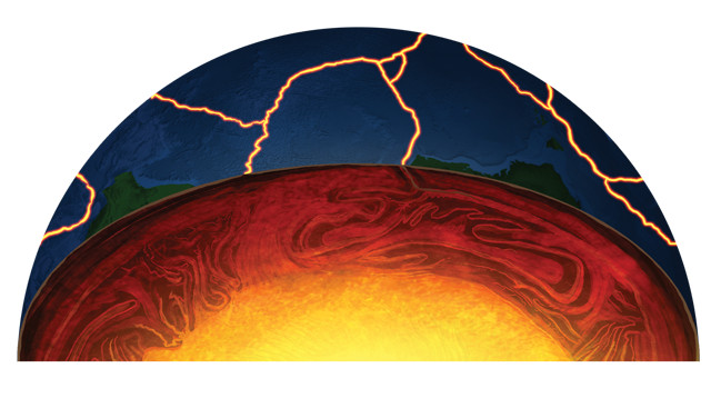
At first, Earth did not look like a place that would eventually support life. But early on, the young, red-hot planet began laying the foundation for becoming a mature, hospitable “blue” planet. One critical development that gave rise to oceans, an atmosphere and the first life forms was the onset of plate tectonics: a shifting puzzle of interconnected slabs of upper mantle and crust that collide and diverge, generating earthquakes, fueling volcanoes, opening ocean basins and raising mountain ranges. But how and when this process — unique in our solar system as far as we know — began on Earth has been an open question since the concept of plate tectonics first coalesced in the 1960s.
The nature of plate tectonics means that the process masks its own origin story: As new oceanic crust is formed at spreading centers, old crust is destroyed in subduction zones. This planetwide surface recycling is so efficient that most oceanic crust is less than 200 million years old and very little continental crust remains from Earth’s early days, making it tricky to figure out when active plate tectonics started. Many scientists think plate tectonics, in one form or another, started about 3 billion years ago, but some think it was more like 1 billion years ago — or less.
“There’s a lot we don’t know about how these plate tectonics systems work in the present day,” says Leigh Royden, a geophysicist at MIT. “Even though the theory of plate tectonics has been well accepted for 50 years now, we still don’t understand the basic organizing principles. If we want to go back in time and have any hope of reconstructing ancient tectonics systems, we need a better handle on how they operate today.”
But even if we had a perfect understanding of modern plate tectonics, that wouldn’t necessarily tell us everything about how the process got started, says Taras Gerya, a geodynamicist at ETH Zürich in Switzerland. “An egg does not look like a chicken,” he says. “Therefore, even if we look at the chicken from a thousand different perspectives, it will not help us imagine an egg.”
Recent advances in geodynamic modeling, seismic imaging and isotope geochemistry have brought about a new understanding of how modern plates interact with Earth’s interior, but major questions still abound. When did the first continents appear? How did the young planet’s lithosphere break into multiple plates? How did the first subduction zones form? And what forces have sustained this system for billions of years?
In this two-part series, EARTH examines how science is tackling some of these daunting questions.
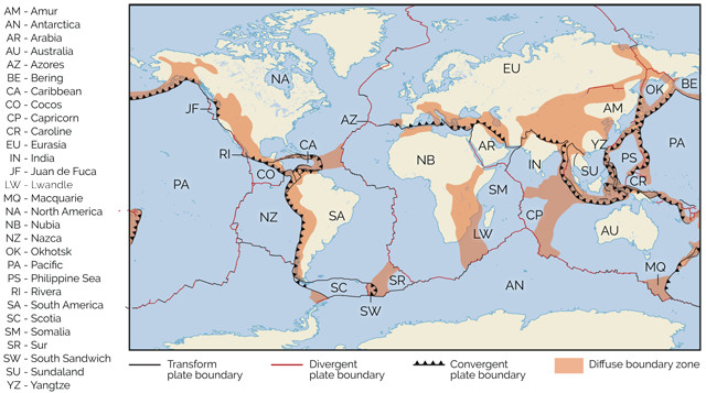
Earth has eight major and dozens of minor plates, each of which is composed of crust and upper mantle. Plate boundaries fall into several categories. Convergent boundaries include subduction zones where one plate dives beneath another, as occurs along the coast of South America, and continent-continent collisions, such as where India is colliding with Eurasia and raising the Himalayas. Divergent plate boundaries are where two plates are moving apart and new crust forms as magma rises up to the surface and solidifies, such as at the Mid-Atlantic Ridge. Transform boundaries, where plates slide past one another, occur in places such as the West Coast of North America along the San Andreas Fault. Also noted on this map are "diffuse boundary zones," where wide swaths of crust are deformed due to a faraway boundary. Credit: K. Cantner, AGI/The Geoscience Handbook, 2016.
Earth did not always have plate tectonics. For millions of years after the planet accreted, its surface roiled with a molten magma ocean. Once the planet cooled enough for a crust to form, the surface may have looked more like modern-day Venus, with the crust and upper mantle — collectively called the lithosphere — forming a single unbroken plate. Millions of years later, Earth’s lithosphere broke into plates and developed dense roots that sunk into the mantle, and the pieces began recycling into the mantle via subduction zones.
Earth’s lithosphere is capped by two kinds of crust: oceanic and continental. Oceanic crust is most commonly formed when basaltic magma rises to the surface at mid-ocean ridges, such as the Mid-Atlantic spreading ridge, and is thinner — typically about 7 kilometers thick — and denser than continental crust. Today, continental crust is formed mainly along subduction zones, where partial melting of descending slabs forms granitic and andesitic magmas at volcanoes on the overriding plate. This process produces thicker — up to 70 kilometers thick — and more buoyant crust that is not as easily subducted. But it is not known how continental crust formed in the past.
Subduction zones form where two plates converge and one begins sliding under the other. As old lithosphere is recycled back into the mantle at subduction zones and new lithosphere is formed at spreading centers, the balance of lithosphere on Earth remains relatively constant.
Today, the planet has eight major plates (defined as those with areas over 20 million square kilometers) and dozens of minor plates (between 1 million and 20 million square kilometers) and microplates (less than 1 million square kilometers). While some plates are composed solely of oceanic or continental crust, most major plates contain portions of both. Geologists aren’t sure how the total number of tectonic plates has varied over geologic time, but we do know that, as plates have drifted together and rifted apart again, the number of major continents has vacillated between single supercontinents and the half dozen or so (depending on how you count them) we have today.
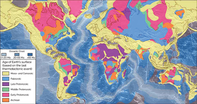
While continental crust that is billions of years old still exists on Earth's surface, most oceanic crust is less than 200 million years old (Ma). Older oceanic crust, which is more dense than continental crust, has long since been recycled in the process of subduction. Credit: U.S. Geological Survey.
Plate tectonics shapes the surface of our planet, but it also runs much deeper: Plate movement is the surface expression of convection in Earth’s interior. Mantle convection is driven by temperature differences between the hot interior and the gradually cooling outer layers of the planet. Cooler, denser material sinking down into the mantle is thought to be the primary driver of circulation, while hotter, less dense material rising to the surface in the form of mantle plumes and upwellings provides a secondary driver. The forces generated by these vertical movements result in horizontal shifts of the tectonic plates at the surface at rates of about a few centimeters per year.
Despite the ubiquity of plate tectonic expressions at Earth’s surface, there’s a lot we still don’t know about how the process operates in the interior, and we know even less about how it all got started.
One of the big questions about the onset of plate tectonics is how subduction got started. Geologists think that the lithosphere of the pretectonics Earth existed as a single plate that covered the whole planet. Massive forces would have been needed to break this single lithosphere into multiple plates and to initiate plates descending into the mantle.
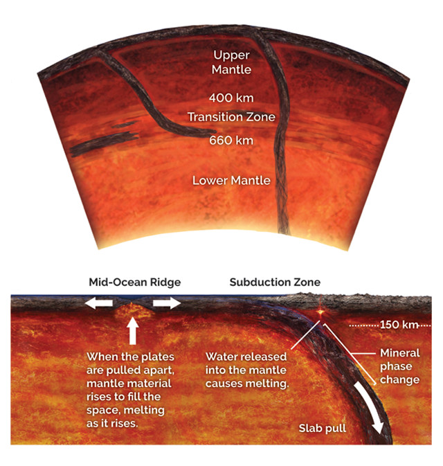
Minerals in lithospheric slabs restructure as slabs descend into the mantle, releasing water and increasing the slabs' densities. The dense, downgoing slabs pull on the parts of the plates still at the surface, driving plate tectonics. Some subducting slabs stall at the transition zone, while others descend toward the core-mantle boundary. Credit: both: K. Cantner, AGI.
“It’s still largely unknown and incredibly controversial how the first subduction zones formed,” says Alan Hastie, a petrologist at the University of Birmingham in England. “The biggest problem is how to break a single continuous plate into multiple plates and then get them to subduct under one another. As we see from India colliding with Asia, it’s not easy to start a subduction zone. It’s easier to raise the Himalayan mountain range than it is to break the crust of the Indian Plate and start a subduction zone. The forces involved are incredible.”
Modern plate tectonic movement is driven primarily by the descent of the subducting limb of a plate, called a slab, pulling the rest of the plate down behind it. The momentum of the massive sinking slabs overcomes the friction generated by the upper mantle adjacent to the slabs as they descend. “Subducting plates drive almost everything that happens with plate motions,” Royden says. “There’s an enormous reservoir of potential energy in subduction zones.”
But it raises a chicken-and-egg question. If plate tectonics is primarily driven by the forces generated by downgoing slabs, how could tectonics have gotten started before there were subducting slabs? It may have to do with heat.
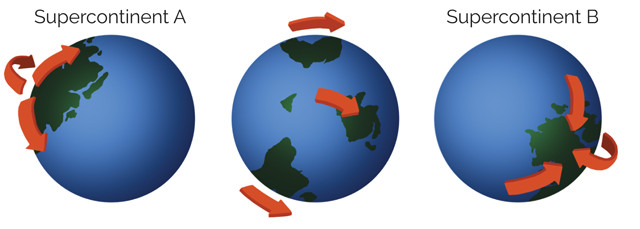
Since continental crust is not dense enough to be pulled into the mantle by subduction, it is moved around on Earth's surface through a cycle of supercontinent formation and breakup. Credit: K. Cantner, AGI.
Today, temperatures in the mantle hover around 1,350 degrees Celsius. But numerical models by Jun Korenaga, of Yale University, and colleagues indicate that about 3 billion years ago, the mantle was hotter by about 100 to 300 degrees. These extreme temperatures — as hot as 1,600 degrees Celsius — had a profound effect on the early crust: Computer models from Gerya published in Nature in 2015 suggest that the hotter temperatures of early Earth may have made for weaker, more easily broken plates. That heat would have also created a very different mantle environment. “If everything was hotter and weaker in the past, it’s easier to imagine plate tectonics on a smaller, local scale with smaller plates breaking apart, sinking down into the mantle, the process starting and stopping over and over again,” says Jeroen van Hunen, a geophysicist at Durham University in England.
But while this hotter and weaker scenario could have helped initiate the process, strength is required to sustain it, van Hunen says. “One of the things you need for the operation of plate tectonics is strong, rigid plates. When a plate gets pulled into a subduction zone and forms a slab, that slab shouldn’t immediately break off, because that would kill all the downgoing momentum,” he says. So, in geodynamic models, which provide us with insights into which mechanisms are physically feasible, he says, “you have to wait a little while after Earth is formed for the interior to cool down a bit in order to get the right conditions for plate tectonics, not just to start, but to be sustainable.”
Environmental conditions may have been different billions of years ago, but, fortunately for modelers, the laws of physics and thermodynamics haven’t changed. “Physical laws during the Archean were the same as in the present,” Gerya says. “Once we figure out which rules are governing geodynamic evolution, we can play with these rules to better calibrate our intuition about the onset of plate tectonics.”
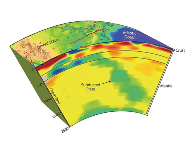
Tomographic imagery of the low-angle subduction of the Farallon Plate (green) beneath North America. The Farallon Plate began subducting under the North American Plate during the Jurassic, and is thought to have been completely overrun by about 50 million years ago. The fate of its remnant slabs as they descended into the mantle may explain several features of the overlying continent, including the rise of the Rockies and the activity of the New Madrid Seismic Zone. The colors show anomalies in rigidity, which correlate with temperature anomalies. Green and blue represent relatively cooler regions, and orange and red represent hotter regions. Credit: Figure based on seismic-tomographic models by Suzan van der Lee and Steve Grand and made under auspices of IRIS.
Empirical data are also needed to calibrate models, and to answer questions about what happens to slabs once they start subducting: Where do they go, and how has this process changed over time?
Deep seismic tomography, which uses seismic waves to image the interior structure of Earth, provides the best look at slab shapes and what happens to them as they descend. Some slabs seem to stall out along the boundary between the upper and lower mantle, located at a depth of about 660 kilometers. “A lot of slabs seem to go down and flatten out at this boundary and in some cases can move along this boundary,” Royden says. But in other cases, such as the Mariana Trench in the western Pacific, slabs appear to keep going down through this boundary into the lower mantle.
Recently, scientists have been working on developing sophisticated models that can rewind the tape and show how slabs move and are assimilated into the mantle over geologic timescales. “High-resolution seismic tomography data are allowing us to trace ancient slabs and subduction zones, and then we can use models to reconcile the position of these subduction zones in the past,” Gerya says. But how accurate these reconstructions are as they retrace slab movements back in time is debated.
“In the last 10 years, our understanding of slab dynamics and how slabs interact with the asthenosphere [the layer of the mantle below the lithosphere] has really increased,” Royden says. “In the next 10 years, insights will come from [advanced] modeling coupled with seismic tomography studies of slab geometry — looking at things like slab dips and rates of subduction.” The next step will then be to look at multiple slab systems on a global scale. Royden and colleagues are currently working on a suite of combined numerical and analytical models to address these questions. Computers are just now able to handle very large, complex models, Royden says. So, “we’re excited to start asking a whole set of global-scale questions that we haven’t been able to explore yet.”
Models are helping to weigh different scenarios, but data from geochemistry, geophysics and the rock record are necessary to validate new ideas, Gerya says. “Data are absolutely critical, even if they are scarce and fragmentary. Discrimination between valid and invalid models can only be made on the basis of data.”
One of the challenges with studying the onset of plate tectonics is that the rock record from the Earth’s early years is very sparse. “There’s just not much to work with,” van Hunen says. Very little rock remains that’s older than 3 billion years, he says, “and anything you find will be very highly deformed. We can look for structures associated with plate tectonics today, such as [those created in] subduction zones or mountain ranges, but they’re almost impossible to recognize in Archean rocks, since all we have are tiny patches that are highly metamorphosed.”
Instead of relying on macroscopic clues found in rocks, scientists are turning to the atomic scale, using isotope geochemistry. “Geochemistry can tell us a lot about the deep past,” van Hunen says. “Even in the tiniest rock, the chemistry will be intact.” Over the last few years, researchers have refined several isotopic tools that may serve as geochemical fingerprints of ancient plate tectonic processes.
Geochemists use two types of isotopes to study the history of rocks and minerals: stable and radiogenic. Stable isotopes occur in different ratios in different geological settings (such as in the mantle versus the crust), so these isotopes, such as oxygen-18 and oxygen-16, can be used to determine where different magmas originated. Radiogenic, or parent-daughter isotope pairs, such as uranium and lead, rubidium and strontium, samarium and neodymium, and lutetium and hafnium, decay at specific rates and can be used to evaluate the timing of geological processes, such as when the continents formed. These isotopes also fractionate differently in different magmatic settings so they can also be used to decipher the processes involved in magma generation and answer questions about how rocks — and continents — formed.
Isotope geochemistry may address one of the biggest mysteries surrounding the onset of plate tectonics: when and how continental crust began forming. “Isotopes of oxygen, hafnium and uranium-lead measured in the mineral zircon can tell us about the formation of new crust from the mantle and the timing of reworking of continental crust during orogenic [collision, mountain-building] events,” says Bruno Dhuime, a geochemist at the University of Bristol in England. For example, in a 2014 study in Nature Geoscience, researchers used isotopes of uranium and lead preserved in zircon crystals found in ancient rocks in Western Australia to confirm the age of the oldest known continental crust to 4.4 billion years old — indicating that continental crust started forming only 100 million years after Earth’s formation, long before the onset of plate tectonics.
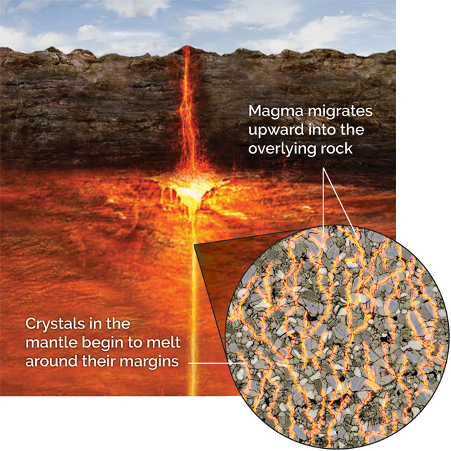
The bulk of continental crust is thought to have formed prior to plate tectonics starting on Earth. Some researchers suggest that the continental crust could have formed by mantle plume-like volcanism. Evidence for this early crustal formation comes from isotopic signatures preserved when certain elements diffused into the liquid magma when melting occured in the mantle. Credit: K. Canter, AGI.
And in a 2012 study in Science, Dhuime and his group looked at ratios of these different isotopes collected in a worldwide database of more than 7,000 zircons to model the volume of continental crust through time. Their research indicates that the overall balance of continental crust — crust added from the mantle minus recycled material back into the mantle — has been more or less constant throughout most of Earth’s history. That suggests, Dhuime says, that plate tectonics has operated more or less continuously since it began, without any interruptions that might have thrown off the equilibrium between the creation of new crust and the destruction of old crust.
As to when it began, further isotopic research has shown that something big began to happen about 3 billion years ago — perhaps the onset of plate tectonics. Using rubidium-strontium ratios in more than 13,000 samples of rock ranging in age from the Hadean to the Phanerozoic, Dhuime and his colleagues found “that the juvenile [continental] crust had a low silica content and was largely mafic in composition [closer to basaltic and made up of dark-colored minerals such as olivine] during the first 1.5 billion years of Earth’s evolution, consistent with magmatism on a pre-plate tectonics planet,” the team wrote in Nature Geoscience in June 2015. “About 3 billion years ago, the rubidium-strontium ratios of the juvenile continental crust increased, indicating that the newly formed crust became more silica-rich and probably thicker,” they wrote.
Rubidium decays to strontium with a long half-life of nearly 49 billion years, making it an ideal tool for studying conditions on early Earth. When mantle material melts to form new crust, rubidium preferentially migrates into granitic melt more so than strontium, so the more felsic (granitic) the crust, the higher the rubidium-strontium ratio will be in that crust. By tabulating rubidium-strontium ratios for those 13,000 samples, Dhuime and colleagues showed that these particular isotopes can be used as proxies for the silica content, which is a known marker for the thickness and volume of early continental crust.
The combination of oxygen, hafnium and uranium-lead isotopes in zircon indicates a change in the volume of crust about 3 billion years ago, which Dhuime and his colleagues say may be related to increased recycling associated with the onset of plate tectonics. In summary, the isotopic clues suggest that continental crust started forming 4.4 billion years ago, formed at a relatively constant rate until 3 billion years ago, then plate tectonics started and began recycling crust at the same rate as new crust was being made, creating a balance that has remained steady to modern day.
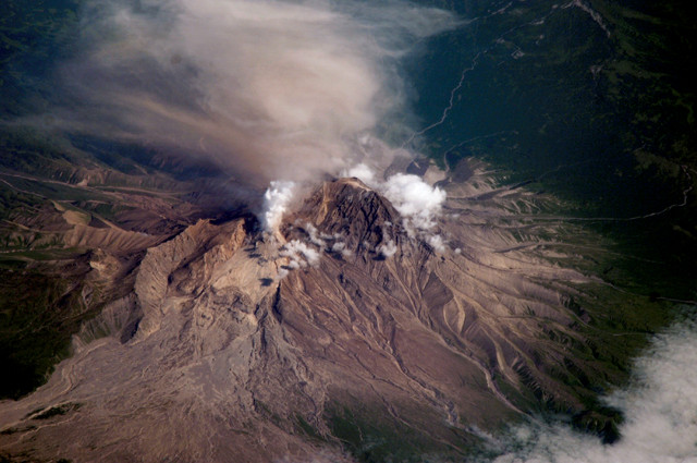
Shiveluch Volcano on Kamchatka in the far east of Russia is one of the most active volcanoes along the "Ring of Fire," a region of volcanism and seismicity along the Pacific Rim caused by subduction of the Pacific and other plates beneath the surrounding continents. Credit: NASA.
“This marks the first time we have gotten an accurate idea of the volume of the continental crust before 2.5 billion years ago, a time period for which the rock record is almost absent,” Dhuime says. “The easiest way to explain this change in [the rate of continental crust production] is that a similar volume of crust was still being generated, but that it was being destroyed more efficiently — which is where the recycling effect of plate tectonics comes in.”
It makes sense that a large volume of continental crust was formed before the onset of plate tectonics, Dhuime says. “Subduction settings are not an efficient way to produce huge amounts of continental crust. Spreading centers and convergent margins may produce large amounts of new crust, but at the same time, crust is also being recycled back into the mantle at subduction zones for a net gain of zero,” he says, so it’s likely that early continental crust was formed through a different process. Perhaps, for example, early crust was formed as a result of melt from a mantle plume solidifying at the surface, as in the case of Iceland or Hawaii today, Gerya says. In that scenario, crust would not have been lost to subduction recycling. Some recycling could still have occurred, either through drips of crust or layers peeling off the underside of the lithosphere, but neither of those processes required plate tectonics to be operating, Gerya says.
Some models, including those proposed by Dhuime and colleagues, suggest that about 70 percent of the present volume of continental crust was formed before 3 billion years ago, meaning that whatever mechanism was generating crust prior to the onset of plate tectonics was a prolific producer.
“Today, continental crust generated in intraplate [hot spot] settings is more mafic while continental crust formed in subduction zones [at volcanoes on the overriding plate] is more felsic on average,” Dhuime says. “Because the crust became more felsic [on average] 3 billion years ago, that may mean that subduction zones were becoming more abundant — an argument for the global onset of plate tectonics around that time.”
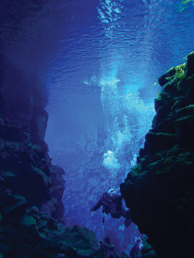
A scuba diver descends into Silfra Canyon in Thingvellir National Park, Iceland, where the North American and Eurasian plates are rifting apart. Credit: Sternzeichen-Kiwi.gif, public domain.
Plate tectonics is such a “big picture” subject, involving the entire surface of the planet and much of its interior, that answers about when and how it began and why it continues will only come from approaching the problem from many different angles. Only by combining multiple lines of evidence, such as geochemistry, geodynamic modeling and seismic imaging, to look at all levels of the Earth system, from the highest mountain ranges to the depths of the deepest ocean trenches, and all the way down into the lower mantle — over the last 4 billion years of geologic history — will scientists be able to piece together the puzzle of conditions that kick-started plate tectonics.
To that end, researchers have organized a series of international conferences on plate tectonics, which have been held occasionally since the early 1960s. “Experts have to interact with other experts,” says Bob Stern, geologist at the University of Texas at Dallas, who, along with Gerya, helps organize the meetings. “My insights are all geological, and I have a lot of respect for the insights geodynamicists and geochemists can contribute to this subject.” The last meeting was in 2016 at ETH Zürich in Switzerland and the next will be held in 2018 at Laurentian University in Ontario, Canada. “That’s a big metals school, which is a community we haven’t brought into these discussions yet,” Stern says. “I’m interested to see what metallogenesis [the study of the origins of ore deposits] can tell us about the beginnings of plate tectonics.”
It may seem like a planetwide process like plate tectonics would have left an indelible mark on the Earth, but due to the history-masking nature of crustal recycling and metamorphosis of ancient rocks, a start date is anything but obvious. Last summer, at the plate tectonics conference in Switzerland, 45 out of 65 participants agreed that plate tectonics likely began about 3 billion years ago, during the Archean. The other third either argued that some form of plate tectonics began as early as 4.2 billion years ago, or that the process began much later, about 1 billion years ago. The latter group, including Stern, bases their thinking on the records of geologic features that require plate tectonics to form them: ophiolites (fragments of oceanic lithosphere emplaced on land), blueschists (oceanic crust metamorphosed in cool subduction zones) and ultra-high-pressure terranes (fragments of continental crust carried to mantle depths of 150 kilometers or more before being exhumed).
Consensus may be a long way off, but in some ways, everybody might be right: Perhaps plate tectonics itself has gradually evolved to operate how it does at present over billions of years, such that it’s looked different at different times in Earth’s past. “I think we all can agree that the transition to plate tectonics was not abrupt,” Gerya says. “Something started happening around 3 billion years ago, but it did not look at all like our present plate tectonics.” Subduction probably didn’t start with one big cataclysm, but rather a series of starts and stops that left the lithosphere scarred just enough to gradually break it into individual plates, he says.
The onset of plate tectonics would have also produced widespread changes in the planet’s atmosphere, hydrosphere and biosphere. “Plate tectonics didn’t happen secretly. Its onset [would have been] reflected on the surface in myriad ways,” Stern says. “Whenever it happened, we are looking for a major turning point in Earth’s history.”
Next month, we will look at how changes to the atmosphere, hydrosphere and biosphere wrought by plate tectonics helped set the stage for the evolution of life on Earth.
© 2008-2021. All rights reserved. Any copying, redistribution or retransmission of any of the contents of this service without the expressed written permission of the American Geosciences Institute is expressly prohibited. Click here for all copyright requests.